Showing posts with label Agas Map of London. Show all posts

05 July 2026

Old Jewry

In the City of London there is a street still called Old Jewry, currently dominated mostly by financial offices. In 2001 the remains of a mikveh (ritual bath, requiring fresh flowing water) was discovered in the area, attesting to its former Jewish occupation. It would have been abandoned when the Jews were expelled in 1290 by King Edward I.

(The illustration shows Old Jewry on the Agas Map, a woodcut made of London probably in the 1560s. It shows Old Jewry [in yellow] linking Poultry Street to Gresham Street. The street is still called Old Jewry, as you can see in the illustration to this 2012 post.)

Although Jews could travel anywhere and any time, they likely came to England in larger numbers from Rouen after 1066, when William invited them to take up residence. By that time Jews were well-known as money-lenders, and William knew he would need money to finance his consolidation of his new country.

Because of their financial importance to the Crown, London Jews were given rights by some kings. William's son William Rufus even brought rabbis and priests together in London to debate religion, teasing his priests that if the Jews won then Rufus would convert.

After the suspicious death of Rufus, Henry I continued the royal policy of giving the Jews privileges unavailable to regular subjects. Jews were a valuable source of financial support; the king would occasionally tax them to raise money quickly. Henry issued a royal charter giving Jews certain protections and freedoms. Jews were given freedom of movement without having to pay the king's tolls, the right to be tried by their Jewish peers, and the right to swear on the Torah in a court of law.

Besides the mikveh, Jewry street also contained the Great Synagogue, which was closed in 1272 after the death of Henry III—who "supported" the Jews with his charity institution, the Domus Conversorum ("House of Converts") placed on the western edge of London far from Jewry, possibly to help prevent apostasy—and the rise to power of Edward I.

One of the other chief locations of Jews in England after they came from the continent in the 11th century was Oxford, and we'll look at their presence there tomorrow.

05 March 2013

Queenshithe

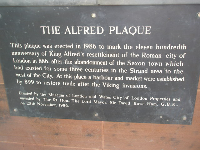
Plaque in Queenhithe.
One of modern London's 25 Wards, Queenhithe, has an ancient history. It is currently quite silted up, but originally was an inlet (probably made during Roman times) for ships to dock at. The name means "Queen's Dock" after Matilda, the wife of King Henry I, when it was presented to her as a source of income from the import duties gathered from ships landing there. The Agas Map of London (c.1560) also names it "Queenshithe"; the "s" has since been dropped.

The site is much older, however. As mentioned, it was no doubt established in Roman times—excavations have found remains of Roman baths in the area. When King Alfred the Great (849-899) "revived" the City of London around 886. Alfred made a gift of it to his brother-in-law Ethelred, and for a time it was called Ædereshyd, or "Ethelred's Dock."

It was an important landing place for ships bringing grain into the city. The nearby Bread Street has existed under that name at least as far back as the Agas Map. Also, Skinners Lane a block away attests to the import of furs, particularly rabbit skins.

It was designated a Scheduled Ancient Monument in 1973, particularly as it is the only surviving site of a once-Saxon harbor. It is therefore protected from random alterations by construction. Its use as a port, however, has fallen off because of its position upriver from London Bridge, preventing large modern ships from reaching it.